July 15, 2006
Volcano Day
Last Saturday was Volcano Day.
 I started out about 8AM in Gresham, OR, just outside
of Portland and also the edge of the land of major civilization.
Up and over Mt. Hood, a pointy snowcapped volcano.
I didn't detour to Timberline, though perhaps I should have--I've skiied in May a
few times, but never stopped
by an activef ski area in July. Then 'down' into the high desert.
The we[s]t side of the mountain is forest, and the east side is too, but it's not
far to the open spaces, where you could see both Hood behind you and Jefferson
(a glaciated peak much like Rainier or Adams) off to the right. Down into the
Deschutes canyon, where there's a nice-looking museum in the Warm Springs indian
reservation, I stopped but didn't go in. Then back up (once I left the canyon, I
don't believe I was below 2000' elevation the rest of the day), through the town
of Madras, across the crooked river to
Redmond (hey, didn't I leave from Redmond the night before), and Bend (the
largest town but completely anonymous since the through road is a 'parkway').
Shortly after leaving Bend, you get to the
Lava
Lands Visitor Center.
I started out about 8AM in Gresham, OR, just outside
of Portland and also the edge of the land of major civilization.
Up and over Mt. Hood, a pointy snowcapped volcano.
I didn't detour to Timberline, though perhaps I should have--I've skiied in May a
few times, but never stopped
by an activef ski area in July. Then 'down' into the high desert.
The we[s]t side of the mountain is forest, and the east side is too, but it's not
far to the open spaces, where you could see both Hood behind you and Jefferson
(a glaciated peak much like Rainier or Adams) off to the right. Down into the
Deschutes canyon, where there's a nice-looking museum in the Warm Springs indian
reservation, I stopped but didn't go in. Then back up (once I left the canyon, I
don't believe I was below 2000' elevation the rest of the day), through the town
of Madras, across the crooked river to
Redmond (hey, didn't I leave from Redmond the night before), and Bend (the
largest town but completely anonymous since the through road is a 'parkway').
Shortly after leaving Bend, you get to the
Lava
Lands Visitor Center.

The visitor's center exhibit is typical forest service visitor center--some rocks, some pictures, ranger talks a few times a day. This fall they will tear it down and replace it with something new by the same architect who built the museum at warm springs. As you may guess from the map, it's sitting right next to a small volcanic cone. You can go right to the top & look around, or or walk around the crater. Take a look at the satellite view and you'll also see that much of the area is still rocky lava flow, still largely barren from a few thousand years ago.
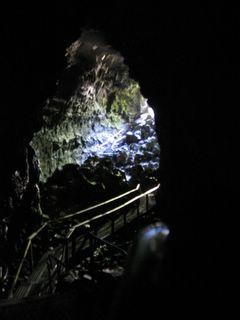
A mile further down the road is the Lava River Cave. From the outside there's just a small gash in the earth, but it's the longest lava cave in Oregon. The caretaker scoffed at my small LED flashlight, but it was more than enough to see where I was going, and once my eyes adjusted you could see pretty well. The people with propane lanterns (reccomended and rentable light source) had the best light, but they probably couldn't see any distance into the cave--I could leave my light off most of the time & see the shapes from the shadows of lantern bearers far away. The neatest section was a double tube. The end of the cave (approximately a mile in) is becomes filled with sand, which some crazy people partially dug out early last century.


Coming out the the real world, there was light again. And heat--the fridge-temp cave had been a nice break from the 85 degree heat outside.
 From there, it was 60 miles to the turnoff to Crescent Lake--a dead straight road
cut through the forest, then a left turn into the park, across the pumice desert,
and up to the crater, just over 7000'. (For reference the Slate Peak road in WA
ends just over 7000' elevation--and is the highest and one of the scariest roads
in the state). Only the west side was open (thanks to snowplows), so around the
west it was, looking out a bit and down at the lake--famed for its blueness.
From there, it was 60 miles to the turnoff to Crescent Lake--a dead straight road
cut through the forest, then a left turn into the park, across the pumice desert,
and up to the crater, just over 7000'. (For reference the Slate Peak road in WA
ends just over 7000' elevation--and is the highest and one of the scariest roads
in the state). Only the west side was open (thanks to snowplows), so around the
west it was, looking out a bit and down at the lake--famed for its blueness.
I grabbed a snack at the gift shop (amazing how good a beef stick + processed cheese food stick taste after a day of riding and caving) and rode back 'down' out of the forest to the high desert and on to Klamath falls. The busy restaurant (and a suggestion from the gas station) was the truck stop across from the Super 8, so there I ate and slept. The big event in town? The Kruise Of Klamath, which klosed the downtown so that muscle cars of various eras could parade on through. Apparently it's one of the biggest events all year.
 The next morning I left around 8AM again, straight out of town towards
California. It's flat to the border, then I had to cross the shoulder of the last
major volcano:
Mt. Shasta, the biggest (and practically southernmost) of the Cascade volcanoes
The next morning I left around 8AM again, straight out of town towards
California. It's flat to the border, then I had to cross the shoulder of the last
major volcano:
Mt. Shasta, the biggest (and practically southernmost) of the Cascade volcanoes
From there, it's all downhill... and every few hundred feet of elevation lost meant another 5 degrees of temperature gained. The forecast in Redding was for 110 that day, and I believe it. So instead of continuing down on I-5, I went up and west towards the coast. But only part way, up high in the mountains.
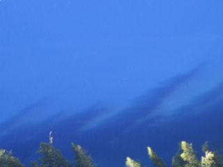
Lassen (the southernmost volcano) should be visible in the background if you squint. Then down back into the central valley--the coastal route would have been nicer, but also taken an extra day. Eventually I had enough of the heat and crossed over to Clear Lake, northern Napa Valley, and Santa Rosa. A few degrees cooler, especially in the trees.

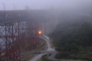 Made it to the Golden Gate just at sunset... not like it mattered, becuase just
as you'd expect on such a day the fog poured across the golden gate, so it went
from sunny and moderately warm to foggy and cold in 10 miles.
Made it to the Golden Gate just at sunset... not like it mattered, becuase just
as you'd expect on such a day the fog poured across the golden gate, so it went
from sunny and moderately warm to foggy and cold in 10 miles.
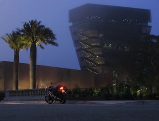
In SF, I went past the deYoung and got some cool pictures, about half an hour after sunset.
Then back to 101, on down the peninsula and out of the fog and back home.